2: Colonial Era
New Amsterdam
The Dutch colonized the island, eventually forcing the Lenape to leave. The Dutch began bringing slaves to New Amsterdam as early as 1626.
Gezicht op Nieuw Amsterdam by Johannes Vingboons (1664), an early picture of Nieuw Amsterdam made in the year when it was conquered by the English under Richard Nicolls. Wikimedia Commons.
  Greene Street
The first residents of the Greene Street block on record were four "half-free" slaves: Gratia D’Angola, Pieter Van Campen, Marycke, and Anthony Portuguese. They were given parcels of land by the Dutch in the 1640s, to serve as buffer against fighting with the Lenape. You can see their names, as well as the names of prominent families like Dyckman and Bayard, on this map of the overlapping Dutch land grants.
Zoom to map
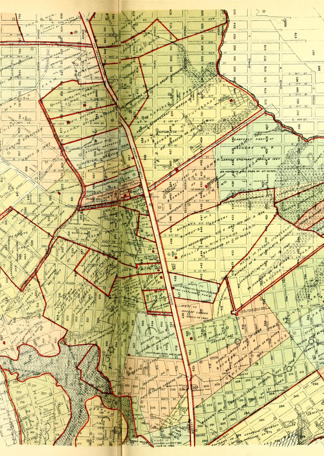
I.N. Phelps Stokes, The iconography of Manhattan Island, 1498-1909:compiled from original sources and illustrated by photo-intaglio reproductions of important maps, plans, views, and documents in public and private collections, 1928.
The Dutch expected New York to be less profitable than Suriname.
When the Dutch ended an inconclusive colonial war with the English in 1667, authorities in the Netherlands had to choose between their profitable slave-run sugar plantations in Suriname or their colony in America. The Dutch chose sugar and Suriname, and the British took control.
Dirk Valkenburg, De suikerplantage Waterlant in Suriname - Plantage van Jonas Witsen aan de Surinamerivier - A plantation belonging to Jonas Witsen on the river Suriname
  Greene Street
The Greene Street area became part of British New York.
Zoom to map
1782 British Headquarters Topography Map, Welikia Project
By 1700, the block was part of the large Bayard farm. The farm stretched from what is now Chinatown to the southern part of Greenwich Village, around 200 acres.
Thomas Howell Greenwhich Village painting, 1768. Sanderson E.W.(2009). Mannahatta: A Natural History of New York City.New York: Abrams, 69.
Nicholas Bayard was a nephew of Peter Stuyvesant, the last Dutch governor of New Amsterdam. The farm produced food to ship to the Caribbean plantations to feed slaves, in exchange for sugar that could be re-sold in America and Europe.
Zoom to map
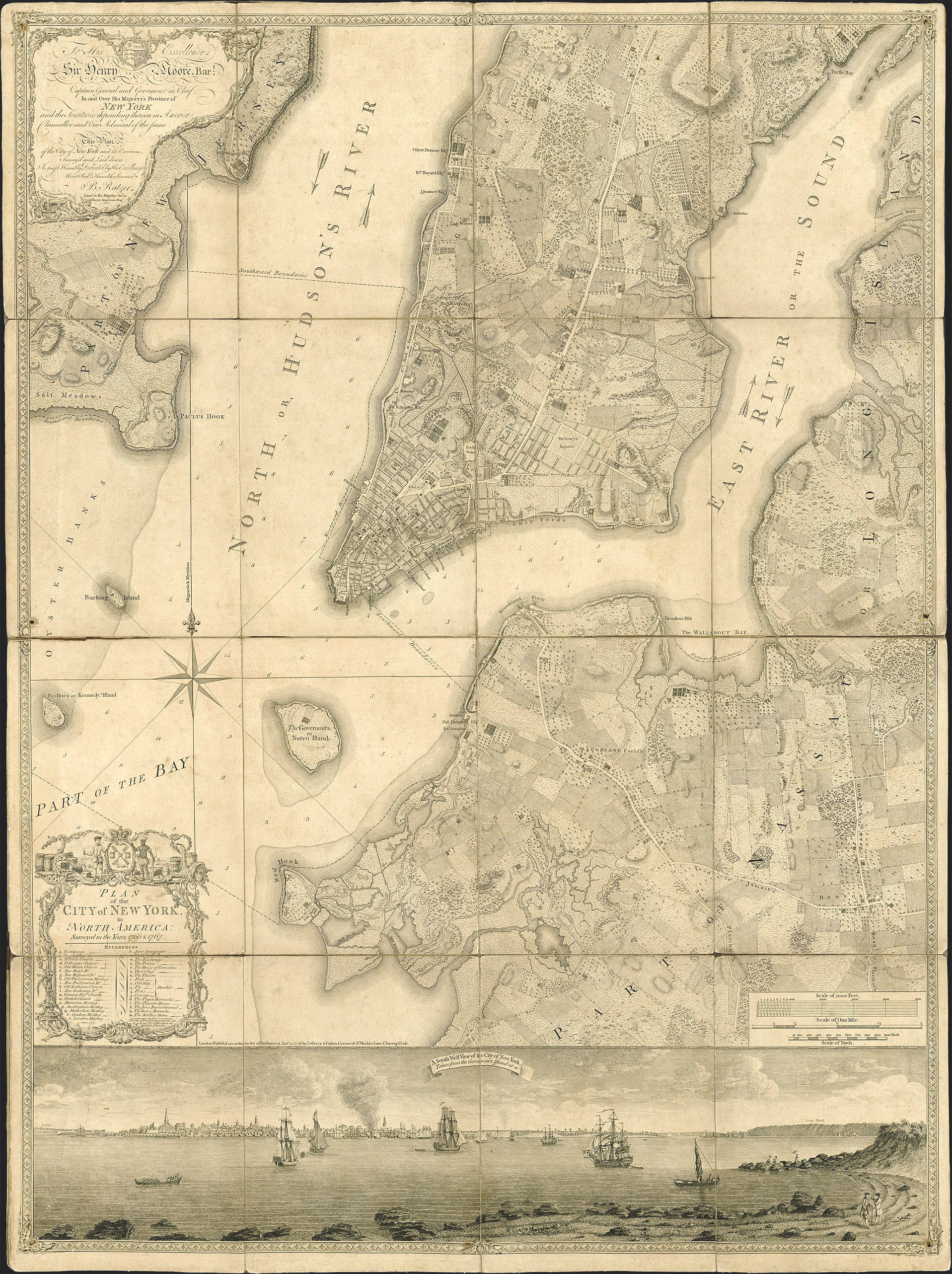
Plan of the City of New York in North America. Bernard Ratzer. ca 1770. Brooklyn Historical Society.
  Greene Street
The Greene Street block, not far from the Bayard farm’s headquarters, lay at the northern edge of the farm, on the outskirts of New York City.
Zoom to map
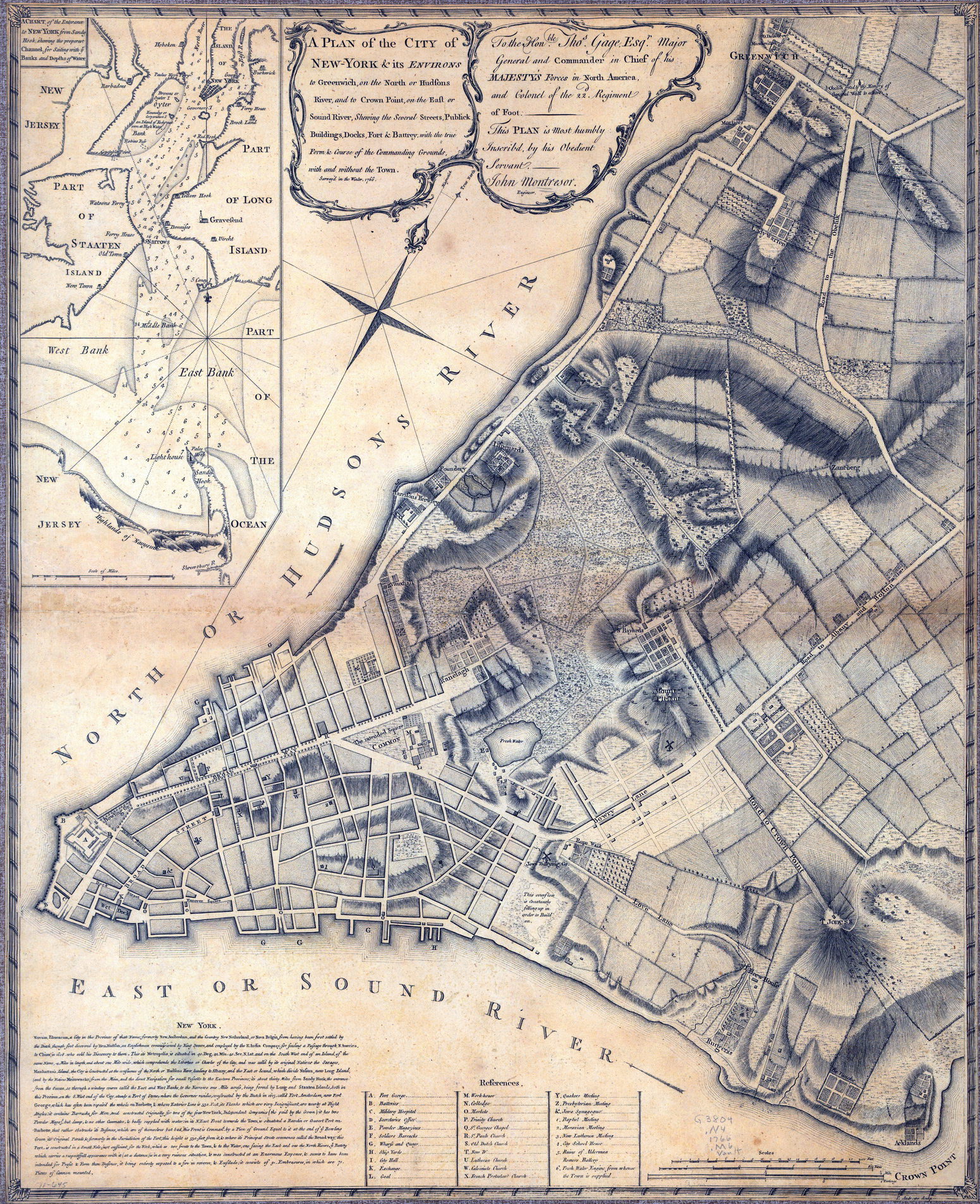
A Plan of the City of New York & Its Environs to Greenwich on the North or Hudson River,…survey’d in the winter, 1766.. Montresor.
  Greene Street
The farm was passed to Bayard’s descendants for several generations, until Nicholas Bayard III went bankrupt and had to sell the farm in 1789.
Bayard Farm Advertisement, 1790: Daily Advertiser
Scroll with or or
or use compass here
Explore captions up here
Access the menu here
Zoom Out